Briscoe County, Texas


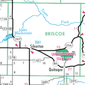


Silverton

Quitaque

Silverton
to
Quitaque,
three arrows
mark sites in
Briscoe County ...
For many centuries, Indians traveled across the rugged territory that today is Briscoe County. Crucial to their routes were streams and rivers, notably, the Prairie Dog Town Fork of the Red River, Little Red River and Tule Creek.
Springs west of Quitaque made the area a favorite meeting place and trading ground for the Comancheros and Comanche Indians.
In the western part of the county, the eastern edge of the Llano Estacado runs north-south. The arrow between Quitaque and Silverton stands at the edge of the escarpment, commonly called the edge of the Texas Caprock.


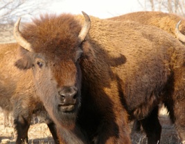
Caprock Canyons State Park is home to the official state bison herd, animals descended from the herds of millions that sustained the Comanche and other hunter-gatherer tribes that lived on the southern Great Plains. Rancher Charles Goodnight, friend of Chief Quanah Parker, saved a remnant of the great herds after the animals had been hunted almost to extinction. Bison that roam Caprock Canyons today are descended from Goodnight’s bison.


HANABA©2010